Utilising drones for weed detection and gap analysis
At Altitude Analytics, we’re always keen to explore what drones and data can do for agriculture. One of our recent R&D projects has been using multispectral imagery to identify weeds and planting gaps in a hail-damaged onion field. Here’s a closer look at how we approached it.
Step 1: Capturing the Field with Drones
Following a significant hail event, we tasked a drone flight over an onion field, which was hit particularly hard, using our trusty DJI Mavic 3M drone. From this, Altitude Analytics collected high-resolution RGB and multispectral imagery that gave us a clear view of the field’s condition. The images showed everything from thriving plants that had survived the storm to areas where things weren’t quite right. The vertical view of the field highlighted both planting gaps and areas of weed infestation.

High resolution drone imagery of a damaged vegetable field (compressed image shown)
Step 2: Classifying Weeds and Plants
Next, we dug into the imagery to classify what we were seeing. Using the multispectral data, we could distinguish between the actual crop and the weeds. Multispectral imagery is great for this because it picks up on differences in plant health and type that are hard to see with the naked eye. The result? A detailed map showing where the weeds were concentrated.

Example of automatic weed detection from Altitude Analytics. Weeds are highlighted in red.
Step 3: Mapping Planting Gaps
We then identified gaps in the planting pattern — places where onions were missing entirely. These gaps might have been caused by anything from planting issues to poor soil conditions. By mapping them alongside the weed data, we could more clearly visualise the field’s problem areas. Below, our method has highlighted both areas of weed growth (pink) and planting gaps (dark blue).
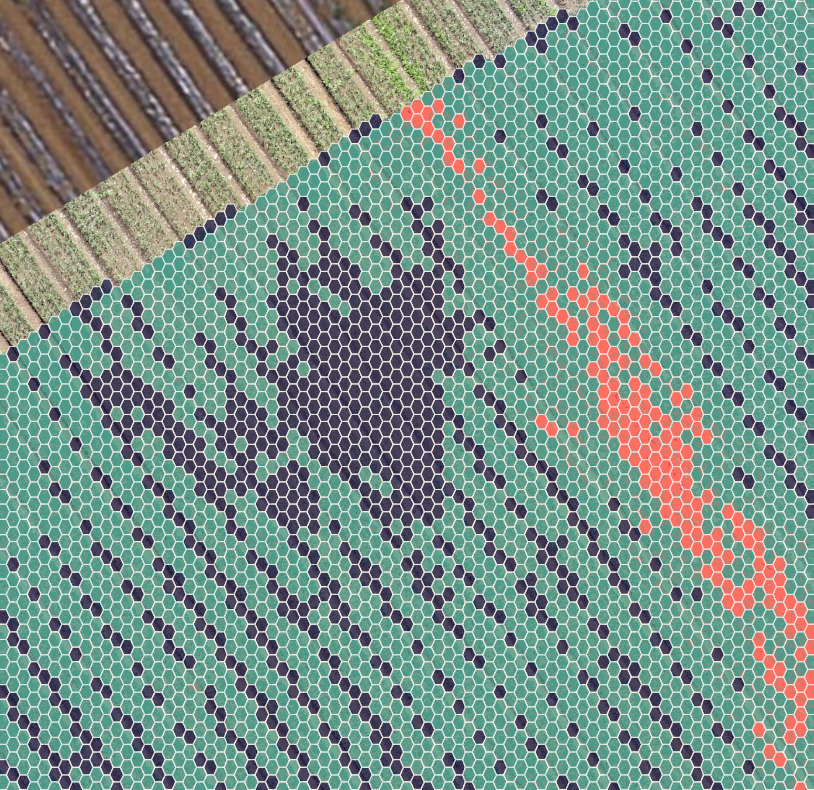
Gap analysis with weeds included in final output. Growers are able to quickly spot areas requiring work.
The Big Picture
Combining the weed and gap analysis gave us and the grower a detailed understanding of the field and where attention needs to be focused. Growers could see precisely where weeds were causing trouble and where replanting might be needed. This is a practical way to make better decisions without guessing what’s happening. Using a drone to capture the data potentially saves the grower hours of field scouting, sampling, and guesswork - Altitude Analytics provides a detailed, quantifiable view of the entire field, allowing for targeted remediation and even spot spraying.
It’s always satisfying to see technology solving real-world problems. In this case, a damaged field got some much-needed insights; the grower could quantify and target their operations, and we learned a lot in the process, too. Whether it’s saving time, reducing chemical use, or just understanding fields better, this kind of work shows how drones and data can make a difference.
That’s the kind of thing that keeps us excited about what we do!
